Khur and Biabanak County
The mysterious silence of the desert, inspiring starry nights, dreamy mornings, spectacular sunsets and finally the colorful spring of the desert are all other manifestations of the charms of the desert. In this way, every time the desert plays a new role and casts a new spell, to foil the plot that the wind, water and sun have in mind for its destruction. He moved to our times and suddenly he found enthusiastic lovers, and he was granted the honor and dignity he deserves.
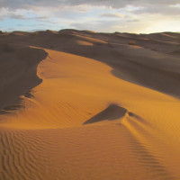
The flowing sands of Kavir-e Mesr which are called Ramal, a quite Persian combination which means “windy sand”, by the locals, is one of the main beauties of the place. Ramals are the main attractions of Kavir-e Mesr. Mounds of flowing sands have stretched to the back of the walls of village houses. The experience of watching the yellow expanse of sands in Kavir-e Mesr will be one of the most memorable things every human eye ever enjoyed.
Takht-e Aroos (the bride’s Bed) and Takht-e Abbasi (Abbasid Bed)
Takht-e Aroos is located at 34.09 northern and 54.45 eastern degrees of Isfahan, in the south of the central huge desert of Iran. in Geographical terms, desert beds are regions which are higher than the surrounding areas while their highest point is even and flat like a bed. The heavy winds in desert areas as well as windy erosion have made flat the mount of these hills over time. In addition, the wind carries on the soft soil left behind the stones and pebbles. Desert beds were considered to be the natural guides in the past. The guidance signs depicted on top of Takht-e Aroos support the claim. Due to their remarkable expanse and heights, beds had been proper natural phenomena used for navigation and orientation in the past. The reason behind the naming of this place is the existence of beautiful depiction on top of the bed. Bride (Aroos) is the symbol of beauty and dignity in desert culture. People in the margin of the desert are used to granting the spectacular places the title of Aroos. Interesting among these kinds of naming is Aroosan area located in the east of Kavir-e Mesr, the other village with the same name in the south of Khour as well as Takht-e Aroos.
Takht-e Aroos is one of the most beautiful desert regions in all around the country. you can see the hills of flowing sands, Chal-e Salkanoun and Mesr Village on top of Takht-e Aroos, in the southern landscape. The broad hills of flowing sands and Takht-e Shour are visible from the north and Damghan mountains, Damavand peak (in a clear air) and wetlands of the central desert are seen from the northwest. Takht-e Abbasi has no plants and the abundance of the pebbles indicates blowing heavy winds in the region. The dominant wind here is western-eastern one which is recognizable from the form of sand hills next to Takht-e Abbasi. The erosion has given the eastern side of the bed a stair-stepped shape with beautiful appearance. The peak of Takht-e Abbasi is placed at the height of 867 meters above sea level and 40 meters above the neighboring plain. The walls of the bed are made of sand, lime soils and marl on which the pebble coverage is apparent.
Kavir-e Neyzar in Mesr Village
Kavir-e Neyzar in Mesr Village is placed six kilometers away from the village in the northeastern Isfahan province. Neyzar is located at 54.48 eastern and 34.05 northern degrees. Being surrounded by flowing sands has given a special appearance to the place. It is the main habitants of the region’s wildlife. Straws reach the heigh of four meters in some points. Kavir-e Neyzar is a proper place for wildlife photography. The reason behind the formation of the reed and its source is a devastating flood in 1977 which made a huge lake in the current place. The lake was dried up over time however, the route of water, which was flowing in the past, underneath the sands and ground of the region directs agricultural wastewater of Amirabad village to enter the layers of ground and then, come to the surface to make the reed. The water of the reed goes below the surface of sands again after moving nearly two kilometers on the surface and it goes up one more time in the region of Salt Lake of Salkanoun. The difference this time is that due to the saltiness of surrounding ground of the lake, the water gets saltier, so that the remained route of stream is covered by salt at the lower areas of lake. The margin of the reed is full of sand-friendly plants including Haloxylon, Calligonum, Tamarisk, Astragalus Squarrosus, Stipagrostis plumosa, Smirnovia turkestana Bunge etc. The animals living here include wolf, sand fox, sand cat, jackal, caracal, crested lark, Muscicapa striata, falcon, rollers, Common buzzard, Meriones, Jaculus, gerbils, Phrynocephalus, Blackstart, Schokari sand racer, Saw-scaled vipers, Spalerosophis diadema and different species of scorpions. Due to the humidity of the region, a variety of insects like mosquito and fly are abundant here specially when the weather is getting warm.


